160
160
Sep 30, 2010
09/10
by
WUSA
tv
eye 160
favorite 0
quote 0
we'll show you first of all, down in southern maryland. st. mary's county, calvert county, getting the moderate to heavy rain starting to move back in. st. leanard, north beach, you had already been hammered from the rain fall this morning. let's go to the storm total rain fall. this is already on the ground. 8 inches here. we have 10 inches plus in some areas between st. mary's city and lusby and you will get more. we will go quickly west of washington, d.c. a line of very strong thunderstorms. in fact, that's why all the flash flood warnings have been issued. to over northern virginia, manassas. that line of thunderstorms will continue a northerly movement and that will have heavy rain fall. i don't doubt, 1 to 2-inch rain fall per hour over the next several hours. we will fill in more rain here in washington through the next several hours. topper. >> let's look at the model now. this is our rain potential and again, you see the sharp edge of some pretty significant rain. an inch or so up to 5 inches of rain. that's why we are saying an addi
we'll show you first of all, down in southern maryland. st. mary's county, calvert county, getting the moderate to heavy rain starting to move back in. st. leanard, north beach, you had already been hammered from the rain fall this morning. let's go to the storm total rain fall. this is already on the ground. 8 inches here. we have 10 inches plus in some areas between st. mary's city and lusby and you will get more. we will go quickly west of washington, d.c. a line of very strong...
165
165
Sep 30, 2010
09/10
by
WUSA
tv
eye 165
favorite 0
quote 0
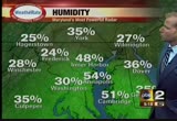
we have had isolated warnings earlier across southern maryland. that's a problem, too, this morning. heavy rain out there. the momslikeme.com bus stop forecast, 59 to 73. today, rain and thunderstorms mid to upper 70s. maybe a little bit less action here late this afternoon. tonight, rain will taper to showers. breezy. 56 to 64. northwest winds 10 to 20. and then tomorrow, maybe some early showers east. otherwise partly sunny and highs near 75. 77 in cambridge. the warm air is streaming in from the atlantic coming up the bay. still around 60 in the shenandoah valley. we sit at 70-degrees in washington with the heavy rain. humidity is 94% and still a northeast wind where 77 cambridge. their winds are from the southeast and the moisture continues to stream up. look at this, right in there from the atlantic. meteorologist devon lucie has been with me all morning. he's in the web center. >> if you log on to wusa9.com. the first thing you are going to see when you log on is our interactive radar. on the main screen, you can zoom in and move the radar h
we have had isolated warnings earlier across southern maryland. that's a problem, too, this morning. heavy rain out there. the momslikeme.com bus stop forecast, 59 to 73. today, rain and thunderstorms mid to upper 70s. maybe a little bit less action here late this afternoon. tonight, rain will taper to showers. breezy. 56 to 64. northwest winds 10 to 20. and then tomorrow, maybe some early showers east. otherwise partly sunny and highs near 75. 77 in cambridge. the warm air is streaming in from...
187
187
Sep 30, 2010
09/10
by
WUSA
tv
eye 187
favorite 0
quote 0
telling us four plus inches in southern maryland. click on the storm reports if you go the weather tab. submit your report and get it to our in box and keeps us updated on what is coming down where you are. >> calvert and sane mary's county, four plus inches already. the tornado watch we are talking about. it covers fairfax, prince william, points east until 1:00. we are watching the storms moving in to southern maryland. it's going to be a mild morning around here and even in to the afternoon as temperatures in the upper 70s with the heavy rainfall expected. the seven-day forecast, we will see rain and showers on the through early friday. especially east of town. friday afternoon 74. saturday 70 and then cooler on sunday with a passing shower 62. angie? >> oh, wait. word of a tornado warning. let's go over to live doppler 9000 hd and look at that real quick. southeastern calvert. eastern st. mary's talking about the storms until 7 a.m. tornado warning southeastern calvert and eastern st. mary's. pax river, lusby, leonardtown over to
telling us four plus inches in southern maryland. click on the storm reports if you go the weather tab. submit your report and get it to our in box and keeps us updated on what is coming down where you are. >> calvert and sane mary's county, four plus inches already. the tornado watch we are talking about. it covers fairfax, prince william, points east until 1:00. we are watching the storms moving in to southern maryland. it's going to be a mild morning around here and even in to the...
109
109
Sep 17, 2010
09/10
by
WUSA
tv
eye 109
favorite 0
quote 0
and southern maryland and in the upper 70s in the north neck. you see highs 81 to 86. so drier air coming in. 78 and sunny at noon and 81 and sunny for the 5:00 p.m. drive home. but we're worried about the driver in right now. >> i know. let's talk about connecticut avenue. you're being forced to exit ton connecticut because it is closed due to some accident cleanup once you get on connecticut, take jones bridge road and take that over to 355 and that will get you back on 495. 95 and the bw park way nice and green. as you move it outside, virginia 66 moving well here and it makes your way in towards the beltway. virginia 95 headed northbound, we're finding drivers moving the speed, making their way out of springfield into the mixing bowl. and staff virginia and 218 remains closed because of an accident cleanup as well. back to you. >>> metro transit is trying to find a new way to stop a big surge in crime. the transit agency said it recorded just under 1100 assaults, thefts or other crimes over the first six months of this year. and nearly double the 575 crimes in 2006
and southern maryland and in the upper 70s in the north neck. you see highs 81 to 86. so drier air coming in. 78 and sunny at noon and 81 and sunny for the 5:00 p.m. drive home. but we're worried about the driver in right now. >> i know. let's talk about connecticut avenue. you're being forced to exit ton connecticut because it is closed due to some accident cleanup once you get on connecticut, take jones bridge road and take that over to 355 and that will get you back on 495. 95 and the...
156
156
Sep 29, 2010
09/10
by
WUSA
tv
eye 156
favorite 0
quote 0
and some of the rain is actually already heavy in southern maryland. we'll go up to return county and annapolis. you have some showers, which are about to move in to you. shady side to north beach you have wet weather. southern portions county and lighter rain. in st. mary's county, leonardtown, st. mary's city across the river toward new land, reedville. jan is four tenth of an inch this morning. really coming down. and this is lifting off to the north. temperatures will hold where they are in the 60s to around 70. it is 66 in fredericksburg. orange is 62. and look, where it is raining in cambridge 63. easton 68 but you will likely see a few degrees chopped off once the rain moves in. light showers at national, 68. dew point in the 50s. that's coming up and the winds from the east will be coming up as well as the storm system is actually part of a complex system. nicole down here. all of this moisture is streaming to the north and it will redevelop in to an extra tropical or post tropical storm but the moisture is here and it's coming and there's a lo
and some of the rain is actually already heavy in southern maryland. we'll go up to return county and annapolis. you have some showers, which are about to move in to you. shady side to north beach you have wet weather. southern portions county and lighter rain. in st. mary's county, leonardtown, st. mary's city across the river toward new land, reedville. jan is four tenth of an inch this morning. really coming down. and this is lifting off to the north. temperatures will hold where they are in...
164
164
Sep 30, 2010
09/10
by
WRC
tv
eye 164
favorite 0
quote 0
southern maryland has had almost four inches of rain. radar showing waves of modere to heavy rain that have been coming through over the last three hours causing flooding. get reports of high water, now many creeks and streams overflowing thr banks in northern virginia, the district of columbia and much of maryland this morning as the waves of heavy rain continue to move on through. in addition we have a tornado watch in effect for the area until 1:00 this afternoon. that meanshat an individual storm cell could proce a funnel cloud between now and 1:00. don't have any reports of that now. just very heavy rain. that will be the big story today with flooding off and on throughout the rest of the day. then tomorrow, after we dry out, late tonight, we'll have the winds picking up out of the northwest. gusting to ound 30 miles an hour. rtly cloudy into the mid 70s. then a cooler weekend to follow morning lows 40s. afternoon highs climbing into the 60s. a look in next week and an expanded report will be coming up in ten minutes at 5:51. now le
southern maryland has had almost four inches of rain. radar showing waves of modere to heavy rain that have been coming through over the last three hours causing flooding. get reports of high water, now many creeks and streams overflowing thr banks in northern virginia, the district of columbia and much of maryland this morning as the waves of heavy rain continue to move on through. in addition we have a tornado watch in effect for the area until 1:00 this afternoon. that meanshat an individual...
423
423
Sep 24, 2010
09/10
by
WUSA
tv
eye 423
favorite 0
quote 0
they have a bay breeze going on and 93 in southern maryland. came bridge is 91. it's 94 in fredericksburg. 90 in frederick and martinsburg. winchester 92 and lurery and gaithersburg. when you factor in the humidity which is high in the bay you have mid to upper 90s on the heat index values. it feels like 90 here in washington. dew point upper 60s and mostly sunny skies. not much relief yet but a front is coming. you can see it to the west past chicago. the front will move to the east and this one means business, folks. warm through tonight and warm in the morning. the front not much in the way of rain with it. it comes through and may touch off showers to the west in the afternoon and sunday, low pressure starts to ride up the front. clouds and northeast flow. we could have some showers south and east by the afternoon. it is going to feel a lot more autumnal. let's talk about the tropics. coming in to nicaragua and heavy rain. the problem is that matthew will be going over land, slowing down. a lot of rainfall is expected across mexico and central america. look a
they have a bay breeze going on and 93 in southern maryland. came bridge is 91. it's 94 in fredericksburg. 90 in frederick and martinsburg. winchester 92 and lurery and gaithersburg. when you factor in the humidity which is high in the bay you have mid to upper 90s on the heat index values. it feels like 90 here in washington. dew point upper 60s and mostly sunny skies. not much relief yet but a front is coming. you can see it to the west past chicago. the front will move to the east and this...
122
122
Sep 17, 2010
09/10
by
WUSA
tv
eye 122
favorite 0
quote 0
and the mid-70s really confined to the southern suburbs in maryland and newland. so we're looking really nice and plenty of sunshine and north west winds and high 81 to 86. front clear and -- tonight clear and cool. great friday night football weather. and lots of 50s to start your saturday. and sunny and gorgeous saturday. 79 to 84 with light winds. chamber of commerce happy with a forecast like that last night we had the showers and storms that pushed through. and look at this, just before 1:00, the heavy showers and thunder from carol county and frederick and montgomery and culpepper and coming in towards charles county that pushed in this morning and we're left in good shape. temperatures have cooled off significantly behind the front into the 50s and 60s. winchester is down to 62. 76 in richmond and 68 in fredericksberg. a few clouds and we'll call it partly cloudy but the winds have charged northwest at eight. this is bringing in cooler and drier air for the next couple days. yesterday we hit 91. plenty of sunshine into saturday. we'll see a few clouds on su
and the mid-70s really confined to the southern suburbs in maryland and newland. so we're looking really nice and plenty of sunshine and north west winds and high 81 to 86. front clear and -- tonight clear and cool. great friday night football weather. and lots of 50s to start your saturday. and sunny and gorgeous saturday. 79 to 84 with light winds. chamber of commerce happy with a forecast like that last night we had the showers and storms that pushed through. and look at this, just before...
239
239
Sep 14, 2010
09/10
by
WJLA
tv
eye 239
favorite 0
quote 0
a quick spin into southern maryland. a nice trip on route 4, 5, and good on 95 and the baltimore washington parkway between thurgood marshall airports and the beltway. southbound on 270 is where we usually see actions starting. moving frederick into montgomery county looks good. looks good on the green light. route 7 looks quiet into tysons. 66 and 95, traffic will heat up so on. it's quiet in springfield. north and south on 95 in the camera. back to you. >> thank you. >>> outside, 65 degrees. >> we will be >>> what a shot by louis on killer. >> things never seem to change with baltimore. ray lewis and the ravens defensive unit outlasted the new york jets last night. the new meadowlands stadium that they are sharing with the new york giants. the ravens 110-9. >>> it is oprah winfrey's 25th anniversary and final season. >> she started off with a big bang with one of for a great trade marks, a giveaway. now the highlights. >> it was the beginning of the end. the premiere episode of the final season, oprah gave 300 audience
a quick spin into southern maryland. a nice trip on route 4, 5, and good on 95 and the baltimore washington parkway between thurgood marshall airports and the beltway. southbound on 270 is where we usually see actions starting. moving frederick into montgomery county looks good. looks good on the green light. route 7 looks quiet into tysons. 66 and 95, traffic will heat up so on. it's quiet in springfield. north and south on 95 in the camera. back to you. >> thank you. >>>...
219
219
Sep 30, 2010
09/10
by
WTTG
tv
eye 219
favorite 0
quote 0
mary's county in southern maryland. doppler radar indicates a severe thunderstorm capable of producing a tornado near st. mary's city. the storm is moving to the north at 40 miles per hour. locations that could be impacted include patuxent naval air station, lusby, st. learn arrested reek, places like that. -- st. leonard creek, places like that. the tornado warning is in effect for the next 40 minutes. we'll keep our eyes on that area as well an let you know as more warnings pop up. >> all right. thank you. appreciate it. >> well, september is typically a bad month for the stock market but was there a change this year? >> we'll find out coming up in our business beat straight ahead. >>> you knew it was coming and we will indeed find out if the cost of a postage stamp is going up. the post office wants to raise the price of mailing a first class letter by two cents up to 46 cents. an independent panel is deciding if the post office should get that price hike. their decision is expected at 11:00 this morning. save those
mary's county in southern maryland. doppler radar indicates a severe thunderstorm capable of producing a tornado near st. mary's city. the storm is moving to the north at 40 miles per hour. locations that could be impacted include patuxent naval air station, lusby, st. learn arrested reek, places like that. -- st. leonard creek, places like that. the tornado warning is in effect for the next 40 minutes. we'll keep our eyes on that area as well an let you know as more warnings pop up. >>...
128
128
Sep 27, 2010
09/10
by
WUSA
tv
eye 128
favorite 0
quote 0
highs around 80. 70 southern maryland. low 70s on the delmarva and 50s from hagerstown west toward cumberland and winchester is 59. 63 in centreville and manassas, sterling 62. we have 62 in rockville. 65 here in alexandria. brandywine and crofton and columbia at 64. national is 65. with the light rain out there and the dew.at 63. i want to show you, this low pressure, this is coming up. that's why rain will be off and on through at least tomorrow morning and should be better in the afternoon. 80 tomorrow. afternoon looks better. wednesday 79 and more rain possible on thursday with highs in the 70s. patranya bhoolsuwan, i give you wet streets and that means? >> it's going to be wet and rainy. >> way to take it and run. >> way to take it. thank you, howard. >> it will be wet to start off the week. use extra caution wherever you go. a live picture on 95 northbound from lorton to the beltway. right now we are seeing volume pick up as we speak but no incidents or accidents to report. that's good news. move over to a realtime m
highs around 80. 70 southern maryland. low 70s on the delmarva and 50s from hagerstown west toward cumberland and winchester is 59. 63 in centreville and manassas, sterling 62. we have 62 in rockville. 65 here in alexandria. brandywine and crofton and columbia at 64. national is 65. with the light rain out there and the dew.at 63. i want to show you, this low pressure, this is coming up. that's why rain will be off and on through at least tomorrow morning and should be better in the afternoon....
144
144
Sep 28, 2010
09/10
by
WUSA
tv
eye 144
favorite 0
quote 0
low 70s in tappahannock and southern maryland. a warm air mass is in place. you can tell by the dew.s in the upper 60s and right now reagan national is reporting light rain with a southeasterly wind at six miles an hour. so, what we are watching, this upper level storm. you see it spinning here out of asheville, right up through charleston, the spine of the appalachians. ahead it is it is drawing moisture on top of us and that's why we had heavy rains yesterday afternoon and this morning to the south and west. nine future cast in motion. this will lift north. by the time we get through this afternoon, the front is pushing through, but with sunshine -- and we're already at 72 -- that's why i think we are going to the low 80s this afternoon. tomorrow we start with a little sun early but look at the clouds and showers in the eastern carolinas. they move northward during the day. here we are at 5:00. yes, light ones in the region and watch what happens on tomorrow night and thursday morning, all of the moisture surges northward through virginia in to maryland. so
low 70s in tappahannock and southern maryland. a warm air mass is in place. you can tell by the dew.s in the upper 60s and right now reagan national is reporting light rain with a southeasterly wind at six miles an hour. so, what we are watching, this upper level storm. you see it spinning here out of asheville, right up through charleston, the spine of the appalachians. ahead it is it is drawing moisture on top of us and that's why we had heavy rains yesterday afternoon and this morning to the...
137
137
Sep 17, 2010
09/10
by
WUSA
tv
eye 137
favorite 0
quote 0
last night, showers, only about a couple hundredths here in southern maryland and a quarter inch, so very happy to see that. you'll notice the showers and some of these had an imbredded lightning and thunder as they came through. today we see clouds. they are starting to break up, except in the mountains. the clouds are hanging tough and that's doing a number on the temperatures. 52 in oakland, cumberland is 66. it's chilly there. winchester is 70. and go south, we have 80 from fredericksburg and 82. we sit at 81. just up the road in montgomery county and leesburg, low to mid 70s. so a lot cooler up north than down south. right now, 81. partly to mostly cloudy. dew point is in the upper 50s. and a wind out of the west, northwest. did you see that humidity? only 47% as this storms have left, the front is coming through. you can see the clearing. have to go back to the midwest for the clearing because the elevation helps lift a little bit and produce those clouds. high pressure in michigan, northwest low behind the front. we are drying out and we are going to stay that way throughout m
last night, showers, only about a couple hundredths here in southern maryland and a quarter inch, so very happy to see that. you'll notice the showers and some of these had an imbredded lightning and thunder as they came through. today we see clouds. they are starting to break up, except in the mountains. the clouds are hanging tough and that's doing a number on the temperatures. 52 in oakland, cumberland is 66. it's chilly there. winchester is 70. and go south, we have 80 from fredericksburg...
206
206
Sep 29, 2010
09/10
by
WJLA
tv
eye 206
favorite 0
quote 0
we may see some sprinkles in southern maryland, but a very wet day coming up on thursday. possibly even some flooding coming up on thursday. >>> a big development in battleground maryland. a new poll shows martin o'malley with a pretty substantial lead over bob ehrlich. the poll was just released tonight. o'malley has and 11. advantage. of ehrlich -- o'malley has an 11 point advantage. the poll numbers had the two in a dead heat. this margin of error has 3.5%. >>> a former president is about to give barbara mikulski a helping hand. bill clinton will be headlining a campaign fund-raiser. he will speak on behalf of barbara mikulski in bethesda. >>> democrats are making a nationwide election day pushed by going back to school. younger voters played an important role in president obama's victory. members of his administration are trying to hit pay dirt again. >> put your hands together for the hon. kathy [unintelligible] >> kathleen sebelius joked she was the president's warm-up act, rallying students at maryland. >> we cannot let this country fall backwards because the rest o
we may see some sprinkles in southern maryland, but a very wet day coming up on thursday. possibly even some flooding coming up on thursday. >>> a big development in battleground maryland. a new poll shows martin o'malley with a pretty substantial lead over bob ehrlich. the poll was just released tonight. o'malley has and 11. advantage. of ehrlich -- o'malley has an 11 point advantage. the poll numbers had the two in a dead heat. this margin of error has 3.5%. >>> a former...
163
163
Sep 21, 2010
09/10
by
WMAR
tv
eye 163
favorite 0
quote 0
we have 60 in southern maryland at the river air station, head just to the north and york pa barely hanging on at 41 degrees. typically we will reach our low temperature by 8:00 in the morning. so we could slip a few more notches before now and then. we will average between 45 and 55 and then aiming for a mostly sunny sky with this afternoon's two degree guaranteed high of 78 degrees. let's see what is happening, here is kim. >> thanks, justin. not much happening on the roadways this morning. you will find minor congestion approaching the tunnels. here we have video from a fire overnight that actually had falls road closed between northern parkway and harvest road. falls road is reopened in both directions. the fire cleanup does continue a little bit, but fortunately, all the activity is moved out of the roadway, so traffic is able to flow freely. we are looking good there. as we look at our cameras and drive times, traffic is going to be okay around the area. we don't have any problems on the beltway to let you know about. outer loop lanes going to be on the left hand side of your screen.
we have 60 in southern maryland at the river air station, head just to the north and york pa barely hanging on at 41 degrees. typically we will reach our low temperature by 8:00 in the morning. so we could slip a few more notches before now and then. we will average between 45 and 55 and then aiming for a mostly sunny sky with this afternoon's two degree guaranteed high of 78 degrees. let's see what is happening, here is kim. >> thanks, justin. not much happening on the roadways this...
595
595
Sep 30, 2010
09/10
by
WRC
tv
eye 595
favorite 0
quote 0
so, yes, this storm is right over southern maryland, southern st. mary's county, and continuing track off to a northeasterly track. but that long dark red area did just disapeerks so that's good news. it looks like the storm may be weakening just a little bit, but the still is the potential that this one could be producing a small tornado. we'll zoom in even more to see some greater detail. that is maybe moving toward glen view knolls, lexington park west of you. you may be having some circulation. perhaps a funnel cloud. this one may have actually produced a water spout that perhaps may also form when it crosses the patent river here. as the storm passes overer, it likely may trigger a water spout thatould be like a tornado over water, and they usually have much weaker winds, and that will help to sort of break the storm dn just a little bit. the wider view of the radar showing this is continuing to move to the north. and once again let's look at some ofthe communityies that may be impacted by this and the timing of this, moving off on a north-nort
so, yes, this storm is right over southern maryland, southern st. mary's county, and continuing track off to a northeasterly track. but that long dark red area did just disapeerks so that's good news. it looks like the storm may be weakening just a little bit, but the still is the potential that this one could be producing a small tornado. we'll zoom in even more to see some greater detail. that is maybe moving toward glen view knolls, lexington park west of you. you may be having some...
198
198
Sep 20, 2010
09/10
by
WBAL
tv
eye 198
favorite 0
quote 0
over to annapolis and down into southern maryland, sunny and 79 on tuesday. there are some dangerous rip currents because of hurricane igor well off the coast. the surf and rip currents are kind of dangerous. and land, it is dangerous. -- in a land, it is gorgeous. this was moving just to the northwest of the island did continues to make its way toward the cooler waters of the north atlantic said the weakening trend should continue. the national hurricane center will keep a close eye to see if any more storms pop up in the next week or so. sunny and 79 after a chilly 49 degree morning. isolated thunderstorms possibly wednesday evening, but we will heat up to around 90 degrees for the first official days of fall. they both cool off a bit over the weekend. >> thank you, tom. >> a new fee for the holiday and by avoiding the word free could save you a lot of money. we have the tes in tonight's "consumer alert." >> this is taking your google account to a new level. they may ask you to enter a 6 digit code after your password. it is said to a mobile device connecte
over to annapolis and down into southern maryland, sunny and 79 on tuesday. there are some dangerous rip currents because of hurricane igor well off the coast. the surf and rip currents are kind of dangerous. and land, it is dangerous. -- in a land, it is gorgeous. this was moving just to the northwest of the island did continues to make its way toward the cooler waters of the north atlantic said the weakening trend should continue. the national hurricane center will keep a close eye to see if...
160
160
Sep 24, 2010
09/10
by
WUSA
tv
eye 160
favorite 0
quote 0
look at the warm air we have got. 73 in town. 72 southern maryland. in the 60s from culpeper to luray to oak land in the mid- 60s and locally we have 73 in fairfax. 70 columbia. watch for that spotty fog in our suburbs. right now 73 at national. feeling like 73. dew point 70 with humidity at 90% an the front we are watching is back here with all the showers and storms pushing to chicago and solution. it will be arriving tomorrow but looks like it won't bring much in the way of rain chances until next week as the low rides up. matthew is a tropical storm, may get to nicaragua and honduras and the yucatan in the next couple of days. nothing watch. 95 today. 85 tomorrow. i will be at the terps game with the sun screen on and monday and tuesday, maybe much- needed rain. >> sun burn in september. this doesn't seem right. >>> police activity going on. you want to avoid the area. minnesota avenue anywhere near m place. moving outside, virginia, 66 eastbound. no incidents or accidents out this way. all lanes are wide open from manassas to fairfax to inside th
look at the warm air we have got. 73 in town. 72 southern maryland. in the 60s from culpeper to luray to oak land in the mid- 60s and locally we have 73 in fairfax. 70 columbia. watch for that spotty fog in our suburbs. right now 73 at national. feeling like 73. dew point 70 with humidity at 90% an the front we are watching is back here with all the showers and storms pushing to chicago and solution. it will be arriving tomorrow but looks like it won't bring much in the way of rain chances...
146
146
Sep 27, 2010
09/10
by
WUSA
tv
eye 146
favorite 0
quote 0
southwest winds 10 to 15 miles an hour. 73 now is the warm spot in southern maryland. fredericksburg is 66. 68 newland. 72 reedville. 57 in cross junction where steve is happy to get the rain. winchester 59 and we have low to mid-60s. uniform on the temperatures across the board. seven-day forecast shows a chance of another system to come up the coast by thursday. today, tonight, tomorrow morning, the showers and storms. wednesday looks good. this system on thursday might stay east of us don't be surprised at noon tomorrow you see more sunshine on thursday. the weekend looks cooler. by sunday it will be sunny with highs in the low 60s. it is 6:17. wet roads mean traffic problems. >> that's right. we are seeing it out there for sure. as you can see the inner loop on the capital beltway. this is the trouble spot we are watching this morning. inner loop at connecticut. one crash. second crash inner loop at colesville. as a result delays are backed up connecticut to 95. a live picture to show you what is happening out there. if you are traveling the inner loop in montgomer
southwest winds 10 to 15 miles an hour. 73 now is the warm spot in southern maryland. fredericksburg is 66. 68 newland. 72 reedville. 57 in cross junction where steve is happy to get the rain. winchester 59 and we have low to mid-60s. uniform on the temperatures across the board. seven-day forecast shows a chance of another system to come up the coast by thursday. today, tonight, tomorrow morning, the showers and storms. wednesday looks good. this system on thursday might stay east of us don't...
112
112
Sep 22, 2010
09/10
by
WUSA
tv
eye 112
favorite 0
quote 0
you can see the 60s out there to near 70 in washington. 69, same in southern maryland. it's a little cooler down. 70 in culpeper. 59 in cumberland. that's our cool spot across the region. locally, 58 in laurel. they take the cake but just down the road college park checking in at 70. 67 in brandywine. and 66 in springfield. out west, let me step out for a second. 65 in centreville and manassas. hay market you're one of our cool spots at 69 degrees. dew point's in the upper 50s. you'll recall yesterday these numbers were in the 40s so the humidity is keeping up as well. not only are we going to be hot we're going to be a little humid as well and winds this morning south at 10 miles an hour. until it's pretty quiet out west. showers and storms in south texas. this is what we've got to watch though. it's possible whatever happens in ohio, pennsylvania and connecticut with a little luck will head towards us. unfortunately the upper level wind fiend is stronger in pennsylvania, new york and new jersey. if you're going north today this has a better chance of seeing thundersto
you can see the 60s out there to near 70 in washington. 69, same in southern maryland. it's a little cooler down. 70 in culpeper. 59 in cumberland. that's our cool spot across the region. locally, 58 in laurel. they take the cake but just down the road college park checking in at 70. 67 in brandywine. and 66 in springfield. out west, let me step out for a second. 65 in centreville and manassas. hay market you're one of our cool spots at 69 degrees. dew point's in the upper 50s. you'll recall...
169
169
Sep 22, 2010
09/10
by
WJZ
tv
eye 169
favorite 0
quote 0
with the exception of extreme southern maryland. and extremelier-- extreme lower eastern shore. 89 degrees. compared to 75, 76 yesterday. dew points up to 64. winds southwest at 5. barometer 29.98, falling a tad. the entire region, as i mentioned, with extreme southern maryland, under that watch until late tonight. 89 here. 91 in hagerstown. 80 in ocean city. 93 in washington. that's going to drop with the rain headed our way. cool spot, oakland, at 79 degrees. wind has been out of the south and southwest, which brought this unusually warm air in across the eastern united states. yes, the entire east. to our north, a frontal boundary we told you about. getting very close. the front is going to stall out just across the mason-dixon line. so we will not get into the really cool air until the latter part of the weekend. see these showers popping up? north of that area, it's much cooler and dryer. right now, looks like the front is going to make it this war. and head back to the north and northeast as a warm front. which means thursday
with the exception of extreme southern maryland. and extremelier-- extreme lower eastern shore. 89 degrees. compared to 75, 76 yesterday. dew points up to 64. winds southwest at 5. barometer 29.98, falling a tad. the entire region, as i mentioned, with extreme southern maryland, under that watch until late tonight. 89 here. 91 in hagerstown. 80 in ocean city. 93 in washington. that's going to drop with the rain headed our way. cool spot, oakland, at 79 degrees. wind has been out of the south...
217
217
Sep 30, 2010
09/10
by
WBAL
tv
eye 217
favorite 0
quote 1
that extends south of baltimore city around to the district of columbia and to southern maryland. we have a flood watch in effect. a tornado watch as well is in effect until 1:00 p.m. this afternoon. we have seen some tornadoes around calvert and st. mary's counties. we will have more on all these other things we need to watch out for an into early tomorrow in a little bit. back over to you, mindy. >> an experimental drug could offer a huge relief for knee pain, if it makes it to the market. the drug was effective in reducing pain and increasing mobility in a study group of more than 400 patients. those who took the drug had 60% less pain while walking. sufferers will have to wait longer as studies were halted because the small percentage of patients saw a disease progressed more quickly. 68 degrees and reigning on tv hill. will he or won't he? keith mills has the latest on ray rice's injury. >> this is a live look 695 and liberty road. up next, we'll update weather >> now traffic pulse 11 and insta-weather plus together. >> good morning. sarah caldwell checking on your morning co
that extends south of baltimore city around to the district of columbia and to southern maryland. we have a flood watch in effect. a tornado watch as well is in effect until 1:00 p.m. this afternoon. we have seen some tornadoes around calvert and st. mary's counties. we will have more on all these other things we need to watch out for an into early tomorrow in a little bit. back over to you, mindy. >> an experimental drug could offer a huge relief for knee pain, if it makes it to the...
356
356
Sep 29, 2010
09/10
by
WJLA
tv
eye 356
favorite 0
quote 0
late-day showers starting in southern maryland and pushing off to the northwest throughouñ the evening. the heaviest between midnight and noon. flash flooding possible. two to 4 inches of rain anticipated. not a good rush hour tomorrow. >>> when we say avoid 16th street, we mean employeavoid. this is why. newschopper 7 flying over the mp%or structure fire. more details on this. let's go to that now. >> we're following this breaking news from northwest washington. flames raced through this apartment building on 16th street. emq)gency crews raised at least eople this. courtney robinson is live at the scene with a late-breaking developments.3 to figure out exactly how this fire started, exactly why this fire started. you can see on 16th street, it all began inside an apartment building. you can see the fire trucks over there with the latter's extenddders extended. the fifth floor and a common area. because it started in the common area, it made it difficult for residents to get out through normal exits. many had to sq&l a evacuate. eight people were taken to the hospital. one child was ta
late-day showers starting in southern maryland and pushing off to the northwest throughouñ the evening. the heaviest between midnight and noon. flash flooding possible. two to 4 inches of rain anticipated. not a good rush hour tomorrow. >>> when we say avoid 16th street, we mean employeavoid. this is why. newschopper 7 flying over the mp%or structure fire. more details on this. let's go to that now. >> we're following this breaking news from northwest washington. flames raced...
132
132
Sep 22, 2010
09/10
by
WUSA
tv
eye 132
favorite 0
quote 0
few 50s like cumberland and 70 in winchester and culpeper. 70 in southern maryland. 66 tap hahnic temperature is down to 5959 hay market. 55 in sterlings g. leesburg is 53. 7 this morning in alexandria. national checks in with 68. mainly clear. south winds at 10 and humidity at 70%. we're going to hope for is that some of the moisture that went through chicago last night, ahead of a front, some of it can make its way towards us but this front, the high pressure on top of us is going to keep us in the hot stuff for the next three afternoon and by the weekend that's when things change. here's your seven-day forecast. 90 today and tomorrow. again, that chance of the afternoon storm, 11:00 tonight that's the autumnal equinox. fall begins astronomically. there's a slight chance a shower friday night but later on sunday into monday morning and on tuesday we'll cooldown. have a chance for an occasional shower with temperatures in the 70s for the most part. angie? >>> we're having some technical problems. we're sorry for that. in this morning's living well headlines congress holds a hearing today int
few 50s like cumberland and 70 in winchester and culpeper. 70 in southern maryland. 66 tap hahnic temperature is down to 5959 hay market. 55 in sterlings g. leesburg is 53. 7 this morning in alexandria. national checks in with 68. mainly clear. south winds at 10 and humidity at 70%. we're going to hope for is that some of the moisture that went through chicago last night, ahead of a front, some of it can make its way towards us but this front, the high pressure on top of us is going to keep us...
119
119
Sep 17, 2010
09/10
by
WUSA
tv
eye 119
favorite 0
quote 0
it's 73 in southern maryland. easton 70, 63 in gaithersburg. most of the suburbs are in the 60s. columbia 64 and 64 in howard county and cross junction, 62. 71 and a few patchy clouds out there. and the dew point continues to drop off. and the winds continue to bring in the drier air out of the west. high pressure and n southwestern michigan, this will build in. so we'll be in fine shape. you may see a few sprinkles in the mountains here today. tonight, things clear out nicely and we have a quiet day for you saturday and another quiet one on sunday. slight chance sunday of a shower. karl exploded overnight. now -- be 120-mile-an-hour storm. igor is scheduled to go over berm saturday over bermuda on saturday. -- over bermuda on saturday. low 80s monday. next week we warm up to say good-bye to summer and hello fall wednesday night at 11:09. >>> we're talking about our major morning problems and how they're disappearing before our eyes. first out to 95 northbound and we're watching volume build between 7100 the back wood road that northbound trip starting to fill out a good a conges
it's 73 in southern maryland. easton 70, 63 in gaithersburg. most of the suburbs are in the 60s. columbia 64 and 64 in howard county and cross junction, 62. 71 and a few patchy clouds out there. and the dew point continues to drop off. and the winds continue to bring in the drier air out of the west. high pressure and n southwestern michigan, this will build in. so we'll be in fine shape. you may see a few sprinkles in the mountains here today. tonight, things clear out nicely and we have a...
215
215
Sep 30, 2010
09/10
by
WJZ
tv
eye 215
favorite 0
quote 0
for example, this car became stuck in floodwaters in southern maryland. first respoarnds worked to rescue people and many roadways remain closed at this hour. outside the rain isn't over yet. these conditions are expected to continue throughout the evening. wjz is live with first warning weather. bob turk and bernadette woods. bob? >> a lot of folks -- it's not over at all. there's a huge amount of rain. an additional two to three inches of rain. look at all this stuff just to the south of us and it's generally moving in our direction. look at our local radar. we you can see -- you can see a band west of us. and a heavy band to the east of our region. that all continues to hit off to the north and northeast. let's take another look at some of the rainfall totals, which will be extremely impressive. six inches. most of the area right along the bay. some areas eight or more inches. to the west less. a lot less over portions of delaware. so the real heavy band through there east of baltimore into southern portions of calvert, st. mary's and portions of weste
for example, this car became stuck in floodwaters in southern maryland. first respoarnds worked to rescue people and many roadways remain closed at this hour. outside the rain isn't over yet. these conditions are expected to continue throughout the evening. wjz is live with first warning weather. bob turk and bernadette woods. bob? >> a lot of folks -- it's not over at all. there's a huge amount of rain. an additional two to three inches of rain. look at all this stuff just to the south...
161
161
Sep 14, 2010
09/10
by
WUSA
tv
eye 161
favorite 0
quote 0
southern areas, down in parts of virginia, maybe southern maryland that cud get closer to 85. 53 to 63 tonight with clear to partly cloudy sky and a west wind at 5:00 and the west wind 7:18. i want to talk about the dew points the dry air that's around with dew points in the 40s to upper 50s. don't have a lot of moisture to work with. when the front comes through, it doesn't have a lot to work with. some showers off to the north in new jersey, new england. all we are seeing are high clouds streaming in from the midwest with temperatures in and around the metro. now down to 57 in reston. fairfax is 85. springfield is 62. portion county, brandywine, 60. andrews 61. columbia 60. crofton 59. montgomery county pair of 60s from gaithersburg and rockville. 65 national. dew point of 59. the winds light out of the south southwest at five and a few high clouds around. we'll expand the picture and you can see the clouds streaming in from the midwest with dying showers moving in to illinois. low pressure will perform in the midwest and head this way. a front will be coming this way. and with it th
southern areas, down in parts of virginia, maybe southern maryland that cud get closer to 85. 53 to 63 tonight with clear to partly cloudy sky and a west wind at 5:00 and the west wind 7:18. i want to talk about the dew points the dry air that's around with dew points in the 40s to upper 50s. don't have a lot of moisture to work with. when the front comes through, it doesn't have a lot to work with. some showers off to the north in new jersey, new england. all we are seeing are high clouds...
146
146
Sep 15, 2010
09/10
by
WUSA
tv
eye 146
favorite 0
quote 1
burgess was a half mile away from the southern maryland post office where he worked for 25 years. burgess ' nephew said the family prayed for a better outcome. >> the doctor came back with his head down and we knew he had pass away. head trauma, broken ribs, broken jaw a piece of his lung had to be removed because he had internal damage. >> reporter: police will con to investigate what happened but at this point they believe burgess was at fault. >>> an ice hockey team left homeless after the blizzards of 2010 will soon a have a new home when prince william ice center collapsed under the weight of the snow the group had nowhere to go. but next month they will have a new facility in haymarket. the organization used $400,000 in membership dues to build their own rink. they are hoping to put the ice down this week. this story is from the prince william county page on the news section of our website, news where you live at wusa9.com. there are pages for more than 50 local communities. >>> it is 6:19. >>> ahead a look ahead though football doubleheader on sunday and hernandez looking g
burgess was a half mile away from the southern maryland post office where he worked for 25 years. burgess ' nephew said the family prayed for a better outcome. >> the doctor came back with his head down and we knew he had pass away. head trauma, broken ribs, broken jaw a piece of his lung had to be removed because he had internal damage. >> reporter: police will con to investigate what happened but at this point they believe burgess was at fault. >>> an ice hockey team left...
163
163
Sep 20, 2010
09/10
by
WUSA
tv
eye 163
favorite 0
quote 0
upper 70s for southern maryland and the bay. and the winds will be below small craft advisory criteria tomorrow. 87 on wednesday. near 90 on thursday and friday. that's hot for this time of year. a few storms possible wednesday and thursday. and then maybe a shower friday night with a very weak cold front. temperatures go back down though. low 80s on saturday and then nice to upper 70s on sunday and monday. >> nice. fall is here. >> exactly. >>> coming up next, researchers find that getting the flu vaccine can slower your risk of a heart attack. we'll talk about why. >>> and coming up new at 6:00 ... >> reporter: i'm scott broom in downtown washington where a congressman for colorado has suggested furloughs to help balance the budget. reactions are coming up. >>> the toyota high school play of the day. >> this morning -- or this evening campus correspondent play of the day comes from isaac there abi. and this is the kick off from high point. and there he goes, 80 yards for the score. as they blank the eagles 65-0. and if you wou
upper 70s for southern maryland and the bay. and the winds will be below small craft advisory criteria tomorrow. 87 on wednesday. near 90 on thursday and friday. that's hot for this time of year. a few storms possible wednesday and thursday. and then maybe a shower friday night with a very weak cold front. temperatures go back down though. low 80s on saturday and then nice to upper 70s on sunday and monday. >> nice. fall is here. >> exactly. >>> coming up next, researchers...
192
192
Sep 18, 2010
09/10
by
WRC
tv
eye 192
favorite 0
quote 0
. 66 in southern maryland. beautiful day to be outside today. enjoy the good weather. temperatures in the 50s and 60s back up to our north. that's the air mass coming our way. another cool tonight. dew point temperatures that measures moisture in the atmosphere have been continuing to drop. dry air in place and clear sky overnight toniht wi be a delightfully cool start for tomorrow morning. high pressure is in charge. we get stay dry all weekend long. high pressure in charge for today and for tomorrow. this next weather front is going to come through here about 6:00, 7:00 tomorrowevening. we'll pick up some extra clouds as it comes on by but i don't think it has enough moisture to work with. no rain in the forecast. sunshine tday and delightful. high temperaturesin thor 70s to near 80 degrees. your extended forecast 79 today. 86 tomorrow. a little bit cooler as we get into the early parts of next week but no threat for rainfall until probably friday of next week. so it's a long ways away. more college football.
. 66 in southern maryland. beautiful day to be outside today. enjoy the good weather. temperatures in the 50s and 60s back up to our north. that's the air mass coming our way. another cool tonight. dew point temperatures that measures moisture in the atmosphere have been continuing to drop. dry air in place and clear sky overnight toniht wi be a delightfully cool start for tomorrow morning. high pressure is in charge. we get stay dry all weekend long. high pressure in charge for today and for...
265
265
Sep 29, 2010
09/10
by
WMAR
tv
eye 265
favorite 0
quote 0
rain in extreme southern maryland. down towards richmond, virginia and southbound. our forecast model calls for showers to spread in this afternoon. get heavy towards daybreak. all day tomorrow, heavy downpour and soaker regardless of whether there's a tropical system or not. the general idea is that the back edge tries to swing through by friday evening and friday night. could linger around the bay, eastern shore, beyond that. we have the flood watch beyond thursday evening. potential of a tidal surge, 12:44, actually this is thursday morning, we'll be watching the high tides, watching rainfall, maybe two to four inches. until then, today, just increasing clouds. late day shower possible, will reach 71 degrees. we're back into the mid-60s, we'll look for a wet day tomorrow with high temperatures pushing into the lower 70s. let's check on traffic right now, here's kim brown. >>> on the harrisburg expressway, southbound lanes, traffic moves very well at shawan, however, it does start to slow down and jack once you approach padonia towards 695. as we look at the camer
rain in extreme southern maryland. down towards richmond, virginia and southbound. our forecast model calls for showers to spread in this afternoon. get heavy towards daybreak. all day tomorrow, heavy downpour and soaker regardless of whether there's a tropical system or not. the general idea is that the back edge tries to swing through by friday evening and friday night. could linger around the bay, eastern shore, beyond that. we have the flood watch beyond thursday evening. potential of a...
171
171
Sep 28, 2010
09/10
by
WJLA
tv
eye 171
favorite 0
quote 0
you can see this swath of rain in western maryland and southern virginia now. the yellows and red is the heaviest of the rain. moderate downpours. plu prince william county. clifton, a light little shower. there is the rain -- the heavier showers and embedded downpours are headed your way in frederick and hagerstown. even down towards charlestown. take a quick look at this. the rainfall total. msm airy, mod sunny as well. high temperatures in the low 80's. becoming less humid and the chance of heavier showers wednesday through thursday later on this week. looking great again by the weekend. back to lisa. >> things are looking relatively good on the highway until that comes in. on the beltway, route 4, not too bad now on the wilson bridge. if you're headed to andrews air force base, they had some lingering road work. stay to the left. montgomery county on the beltway, things uneventful. no shine of rain. things looking a little bit damp for us this morning msm in frederick, things are quiet on 270. back to alison. >> your time is 4:41. still to come this morning
you can see this swath of rain in western maryland and southern virginia now. the yellows and red is the heaviest of the rain. moderate downpours. plu prince william county. clifton, a light little shower. there is the rain -- the heavier showers and embedded downpours are headed your way in frederick and hagerstown. even down towards charlestown. take a quick look at this. the rainfall total. msm airy, mod sunny as well. high temperatures in the low 80's. becoming less humid and the chance of...
474
474
Sep 27, 2010
09/10
by
WMAR
tv
eye 474
favorite 0
quote 0
temperatures have bumped up in the past hour, now 70 in baltimore. 68 easton but southern maryland low 70s. that was part of a warm front. that warm front pushed really heavy rain through, in fact over an inch of rain, especially around downtown and south towards glen burnie with minor flooding. more rain coming up behind that. while we go through the day we'll be watching periodic impulses of energy. that will actually spark some more potential flooding. some of the storms could drop an inch to two inches of rain. we're aiming for 72 degrees. we're almost there. low to mid-70s, plan for wet weather on and off throughout the day. >>> very heavy volume around both sides of the outer loop as we look on the west side at liberty road, it's going to be an extra 20 minutes pretty much between 79 a as you approach the -- 795 as you approach the baltimore national pike. as we look at the maps, several accidents, an injury accident in glenarm, harford road and long green pike. expect delays there. another crash in nottingham, honeygo boulevard and belair road. another accident blocking the oute
temperatures have bumped up in the past hour, now 70 in baltimore. 68 easton but southern maryland low 70s. that was part of a warm front. that warm front pushed really heavy rain through, in fact over an inch of rain, especially around downtown and south towards glen burnie with minor flooding. more rain coming up behind that. while we go through the day we'll be watching periodic impulses of energy. that will actually spark some more potential flooding. some of the storms could drop an inch...
118
118
Sep 22, 2010
09/10
by
WUSA
tv
eye 118
favorite 0
quote 1
most of the maryland except for down in st. mary's county. damaging wind gusts and small hail if they get strong enough. we'll watch this from mid to late afternoon. go through 6:00 and you see a few spots of green showing up. sort of like boiling water. bubbles coming just not sure where. we'll watch the doppler closely this afternoon. we quiet down overnight. and then tomorrow we're going to watch it one more time with the heat and humidity. there we go with a few more thunderstorms developing. by the time we get to friday looks like there will be less of a trigger. still very hot. low if not mid-90s across the region. there's our front. that's going to change things for the weekend. temperatures this afternoon they are going to soar. winchester 95. 92 cumberland and lower 80s in annapolis. our seven-day forecast it's hot through friday. again, watch out for storms this afternoon. topper will have the latest through the afternoon fall tonight 11:09. saturday cooling down to around 84. should be a good day. sunday a chance for a shower or tw
most of the maryland except for down in st. mary's county. damaging wind gusts and small hail if they get strong enough. we'll watch this from mid to late afternoon. go through 6:00 and you see a few spots of green showing up. sort of like boiling water. bubbles coming just not sure where. we'll watch the doppler closely this afternoon. we quiet down overnight. and then tomorrow we're going to watch it one more time with the heat and humidity. there we go with a few more thunderstorms...
227
227
Sep 29, 2010
09/10
by
WJLA
tv
eye 227
favorite 0
quote 0
maryland and fredericksburg and pushing north. the heaviest rain it is nice in the break in the dry weather here in times square. george? >> thank you, sam. >>> here in "gma," we've been following the growing problem of bullying in schools and what to do about it. this morning, we have a story of one young man who is taking a stand. 11-year-old tyler wilson wants to be a cheerleader. some bullies teased him about it and broke his arm in a fight. but tyler is not giving up. we'll talk to he and his mom. but andrea canning with his story on what happened. >> reporter: when the fictional football star wanted to join the cheerleading squad on the season premiere of "glee," it made for a funny moment. ♪ >> reporter: but when tyler wilson, an ohio sixth grader joined the flag city youth cheerleading squad in june, it was no laughing matter. the 11-year-old says when word got out he was the only male on the team, he was allegedly teased, then beaten by two classmates that broke his arm. >> it feels horrible that they can't accept me fo
maryland and fredericksburg and pushing north. the heaviest rain it is nice in the break in the dry weather here in times square. george? >> thank you, sam. >>> here in "gma," we've been following the growing problem of bullying in schools and what to do about it. this morning, we have a story of one young man who is taking a stand. 11-year-old tyler wilson wants to be a cheerleader. some bullies teased him about it and broke his arm in a fight. but tyler is not giving...
273
273
Sep 19, 2010
09/10
by
WRC
tv
eye 273
favorite 0
quote 0
mabe a sprinkle far southern pennsylvan. far western maryland. if you're a bengals fan, the bengals are out in cincinnati taking on the bengals today. good weaer for the game out there so no weather related issues. our forecast tomorrow, partly sunny. a touch cooler. we'll make it to 86 today under the increasing clouds. 80 degrees torrow with the returning sunshine. 79 degrees on tuesday. a slight chance, and let's hope it actually come true, on wednesday a slightchance for a shower. a rumble or two and then very mild weather to finish out next week and get into next weekend. we're probably -- i think we're track to have one of the top two or three warmest septembers on record to follow up the hottest summer. >> thank you, chuck. >>> the terps get shell-shocked in morgantown. >> the highlights in this morning's sports in a minute with hakem dermish. >>> college football, maryland taking on number 21 west virginia in morgantown. quarterback gino smith threw four touchdowns giving west virginia a 28-0 lead but may marylandid mount a comeback court
mabe a sprinkle far southern pennsylvan. far western maryland. if you're a bengals fan, the bengals are out in cincinnati taking on the bengals today. good weaer for the game out there so no weather related issues. our forecast tomorrow, partly sunny. a touch cooler. we'll make it to 86 today under the increasing clouds. 80 degrees torrow with the returning sunshine. 79 degrees on tuesday. a slight chance, and let's hope it actually come true, on wednesday a slightchance for a shower. a rumble...
157
157
Sep 15, 2010
09/10
by
WMAR
tv
eye 157
favorite 0
quote 0
maryland, pennsylvania jersey back through virginia, west virginia. but as we look further west our next weather maker is beginning to develop. couple of storms flaring up through central missouri headed in through the southern part of illinois. that same storm system headed our way. we think it will bring some clouds tomorrow afternoon. best chance of rain tomorrow night into the overnight hours. that's actually good time. we don't think we'll get a lot of rain with this storm if we get the rain in the overnight hours it soaks into the ground a little better we could use it. in the meantime high pressure in control. >> that's going to keep dry weather dominating the forecast picture for 24 hours. few clouds build in early in the morning but most of the cloud cover holds out late in the day. rain knocking on our door to the west and then the scattered showers we hope will hold together as they come through the overnight thursday and clear out friday so the weekend with still looks absolutely picturesque and fantastic. out here in the tropics unbelieva
maryland, pennsylvania jersey back through virginia, west virginia. but as we look further west our next weather maker is beginning to develop. couple of storms flaring up through central missouri headed in through the southern part of illinois. that same storm system headed our way. we think it will bring some clouds tomorrow afternoon. best chance of rain tomorrow night into the overnight hours. that's actually good time. we don't think we'll get a lot of rain with this storm if we get the...
172
172
Sep 29, 2010
09/10
by
WJZ
tv
eye 172
favorite 0
quote 0
but first, in southern mexico hundreds of people were evacuated. at least three people died in mud slides associated with the storm. in columbias, dramatic video of a mud slide. rescue workers say none of the 30 people trapped are expected to be found alive. many of them were waiting to change buses on the road below. >>> an ugly incident in texas when a brawl breaks out between coaches in a pee wee game. it started when a coach tried to separate two players who were fighting. the league has banned both teams from further play this season. one of the coaches is suspended for life. >>> chilling scene at the university of texas, a masked man carrying an assault rifle opens fire. the gunman ran into the library where he fired more rounds before turning the gun on himself. he was later identified as a 19- year-old sophomore named colton tulley. no one else was injured by the gunfire. >>> a shooting and subsequent car crash leaves one dead. police say it began when two people were leaving the funeral of a recent homicide victim. they were shot at while
but first, in southern mexico hundreds of people were evacuated. at least three people died in mud slides associated with the storm. in columbias, dramatic video of a mud slide. rescue workers say none of the 30 people trapped are expected to be found alive. many of them were waiting to change buses on the road below. >>> an ugly incident in texas when a brawl breaks out between coaches in a pee wee game. it started when a coach tried to separate two players who were fighting. the...
162
162
Sep 16, 2010
09/10
by
WBAL
tv
eye 162
favorite 0
quote 0
there are still some rainshowers to contend with a round of baltimore area back into western maryland. one final batch of strong storms that prompted tornado warnings earlier this afternoon in parts of eastern ohio. so far the rainfall amounts have not been impressive. we will take what we can get. nothing measurable at bwi .arshall, just a trace theire mid 80 cozy with the normal high down to 78. temperatures running in the low 70's of i-95 into harford county. even cooler out west, parts of allegheny and garrett county, upper the's and low 60's. one more batch of showers coming across eastern ohio arrives later tonight. the last of the shower should be clearing by 2:00 or 3:00 and heading for the coast. a shower or storm through about 3:00 in the morning and then humid conditions give way to a west wind. drier air moves in and a cooling trend toward dawn tomorrow morning. another storm this project high pressure builds then friday afternoon. the futurecast indicates lots of sunshine returning in the afternoon tomorrow, holding on for saturday. a weaker front drugs out of pennsylvani
there are still some rainshowers to contend with a round of baltimore area back into western maryland. one final batch of strong storms that prompted tornado warnings earlier this afternoon in parts of eastern ohio. so far the rainfall amounts have not been impressive. we will take what we can get. nothing measurable at bwi .arshall, just a trace theire mid 80 cozy with the normal high down to 78. temperatures running in the low 70's of i-95 into harford county. even cooler out west, parts of...
250
250
Sep 27, 2010
09/10
by
WRC
tv
eye 250
favorite 0
quote 0
that's now moving up into southern frederick county, maryland. all this action isoving south to north. right now the radarhowing other areas of light blue and dark blue. this is light rain and moderate rain farther to the south from near stafford county and spotsylvania counties, farther down. rich monday, getting more moderate rain, but north of there, it's generally light rain. you see the light blue most of north virginia, panhandle of west virginia. but this is that one very heavy shower right now that moved just north of montgomery county into frederick county. there's also another moderate shower in gaithersburg, and that'going to track the same way. behind that, more coming through. some of the creeks and drains along this train of heavy rain could begun to get a lot of water, and we may see some flooding beginning along some of these creeks here from northern montgomery county down to eastern fairfax and right down near the title potomac just south of alexandria. so watch out, some of those small creeks and streams could get some water en
that's now moving up into southern frederick county, maryland. all this action isoving south to north. right now the radarhowing other areas of light blue and dark blue. this is light rain and moderate rain farther to the south from near stafford county and spotsylvania counties, farther down. rich monday, getting more moderate rain, but north of there, it's generally light rain. you see the light blue most of north virginia, panhandle of west virginia. but this is that one very heavy shower...
300
300
Sep 21, 2010
09/10
by
WMAR
tv
eye 300
favorite 0
quote 0
we are looking at 45 towards yorkpa. 59 in southern maryland at the naval air station. sunshine, not much else to talk about. we'll push it up to near seasonal levels, 78 this afternoon. we are back in the mid 80s by tomorrow. here is kim with a check on that traffic. >> we are still facing some significant delays this morning around the beltway. particularly on the topside of the outer loop. an earlier accident at hartford lane. delays are going to be jammed, almost the entire span of the topside all the way to york road. also working a handful of accidents. another crash in essex at turkey point road. here is megan with your morning news update. >>> good morning, everyone. 28-year-old coil has been found guilty of first-degree murder of his uncle. it took a jury less than two hours to find coil guilty of killing william porter. this is a murder for hire scheme that involved porter's wife. they tried to make the shooting look like a robbery gone wrong, but surveillance showed a different story. >>> a woman is charged with fatally beating her aunt with a club. when poli
we are looking at 45 towards yorkpa. 59 in southern maryland at the naval air station. sunshine, not much else to talk about. we'll push it up to near seasonal levels, 78 this afternoon. we are back in the mid 80s by tomorrow. here is kim with a check on that traffic. >> we are still facing some significant delays this morning around the beltway. particularly on the topside of the outer loop. an earlier accident at hartford lane. delays are going to be jammed, almost the entire span of...
204
204
Sep 22, 2010
09/10
by
WMAR
tv
eye 204
favorite 0
quote 0
low 70s in southern maryland. we pump in a little more heat today. there'll be a small chance of a late day thundershower, west and north of town. we'll slip into the mid-60s overnight. as we head into tomorrow, expecting warmer temperatures. highs upper 80s to around 90. some drivers can honestly say they were late for work because they got stuck behind a broken down boat on the beltway. a truck carrying a boat has broken down. it's blocking two lanes right now. expect significant delays. you can add an extra 20 minutes to your commute if traveling the top side from bel air to york road. crash 95 southbound off to the right shoulder. i-70 westbound has been closed again. only one lane open southbound 295 at 197. >> don't see that every day, a boat on the beltway. >>> baltimore city police commissioner fred bealefeld met with city personnel to review emergency response plans. this meeting comes in the wake of last week's shooting at johns hopkins hospital. the gunman shot the doctor after he told him about his mother's diagnosis. partis killed his mo
low 70s in southern maryland. we pump in a little more heat today. there'll be a small chance of a late day thundershower, west and north of town. we'll slip into the mid-60s overnight. as we head into tomorrow, expecting warmer temperatures. highs upper 80s to around 90. some drivers can honestly say they were late for work because they got stuck behind a broken down boat on the beltway. a truck carrying a boat has broken down. it's blocking two lanes right now. expect significant delays. you...
194
194
Sep 29, 2010
09/10
by
WRC
tv
eye 194
favorite 0
quote 0
leading edge of this tropical moisture into southern virginia now. likely that will be arriving later this afternoon. heavy at times tonight through noon time. dry friday and saturday. jerry, how is the traffic? >> doing pretty well. interstate 66. several stretches now between haymark and manassas east of fair oaks and the capital pelt way. no incidents, just volume. let's head over and see if there's anything to wore about at the american legion bridge, rockville pike doing great. outer loop moving along nicely. travel lanes open both ways. out on the rails. metro and vre okay. one minor delay, mark 503. >>> we're continuing to follow breaking news out of the district. crews on the scene of a fire in the 3100 block of 16 street northwest in the columbia heights neighborhood. news 4's tracee wilkins is on the scene with the latest. good morning, tracee. >> reporter: good morning, joe. this was a terrible fire. what we do know is the fire was started possibly in a hallway, considered the common area of the fifth floor. let me show you what it looks l
leading edge of this tropical moisture into southern virginia now. likely that will be arriving later this afternoon. heavy at times tonight through noon time. dry friday and saturday. jerry, how is the traffic? >> doing pretty well. interstate 66. several stretches now between haymark and manassas east of fair oaks and the capital pelt way. no incidents, just volume. let's head over and see if there's anything to wore about at the american legion bridge, rockville pike doing great. outer...
183
183
Sep 30, 2010
09/10
by
WRC
tv
eye 183
favorite 0
quote 0
huntingtown maryland right there just to the east of that. and it is continuing moving due north, tracking into anne arundel county in the next 15 or 20 minutes. again, other pockets of very heavy rain when you see the dark greens and yellow just to the north of washington, howard county, northern montgomery ounty, western fairfax, pockets of very heavy rain continuing to fall. other pockets of very heavy rain farther to our south now. because of the terrain here with the hills and the foothills of virginia, that water just funnels into these creeks and streams in those deeper valleys. likely there's going to be flooded roads out here. maybe even washed out bridges as the morning progresses. if you see high water do not attempt to drive through any high water. turn around, te another route and definitely do not attempt to do that bause just a foot of water is enough to float a car away, and any time we have these major flooding events weave people stranded in their cars, especially in the morning hours, because now it's so dark you can't tell
huntingtown maryland right there just to the east of that. and it is continuing moving due north, tracking into anne arundel county in the next 15 or 20 minutes. again, other pockets of very heavy rain when you see the dark greens and yellow just to the north of washington, howard county, northern montgomery ounty, western fairfax, pockets of very heavy rain continuing to fall. other pockets of very heavy rain farther to our south now. because of the terrain here with the hills and the...
190
190
Sep 27, 2010
09/10
by
WRC
tv
eye 190
favorite 0
quote 0
light rain in frederick county, northern maryland. another shower moving out of fairfax, southern montgomery county. this is going to continue from time to time here throughout the rest of the day. this is the rainfall totals we have had from this system. not a lot. 0.1. north we have had as much as 0.6. over an inch in charlottesville to the central shenandoah valley. upper 50s and low to mid 60s and eastern shore. low 70s in the mountains of west virginia. we do have more rain on the way. this conveyor belt of moisture off the gulf of mexico into our region. we will continue here throughout he rest of the day. for students waiting for the school buses, bring the umbrella. it's going to be a wet morning. low t mi60s. occasional showers through the rest of the day. heavier downpours this afternoon and this evening. could produce thunder and lightning and damaging winds this afternoon and into this evening. we'll hover near 70 into tonight and tomorrow morning. on tuesday, morning storms should be dissipating. sun pack during the after
light rain in frederick county, northern maryland. another shower moving out of fairfax, southern montgomery county. this is going to continue from time to time here throughout the rest of the day. this is the rainfall totals we have had from this system. not a lot. 0.1. north we have had as much as 0.6. over an inch in charlottesville to the central shenandoah valley. upper 50s and low to mid 60s and eastern shore. low 70s in the mountains of west virginia. we do have more rain on the way....
155
155
Sep 17, 2010
09/10
by
WRC
tv
eye 155
favorite 0
quote 0
mountains of western maryland, west virginia, upper 50s to near 60. the moving color is rain that came throug in a couple waves yesterday overnight and last night. exited north and east. getting heavy downpours in southern new england. highs reaching low 80s. mid-50s. great day for outdoor creation and fun. sunday, partly cloudy, mid-80s. dry into the first part of next week let's check traffic on this friday morning. ashy is with us. how is it looking, ashley? >> good morning. breaking news. we have the beltway shut down. shout down for a better part of the overnight hours between connecticut avue and 355. a hazmat spill. the headlights indicate that all lanes are rpened. you will still see towards the top of your screen still police activity for connecticut avenue. a coupe emergency vehicles pep erred along the shoulder. nothing that's really going to add too much time to your commute. all is quiet and dark along route 7. 28 cutting across the center of your screen with no problems to report. voume on the increase from springfield to newington. expr
mountains of western maryland, west virginia, upper 50s to near 60. the moving color is rain that came throug in a couple waves yesterday overnight and last night. exited north and east. getting heavy downpours in southern new england. highs reaching low 80s. mid-50s. great day for outdoor creation and fun. sunday, partly cloudy, mid-80s. dry into the first part of next week let's check traffic on this friday morning. ashy is with us. how is it looking, ashley? >> good morning. breaking...
558
558
Sep 28, 2010
09/10
by
WRC
tv
eye 558
favorite 0
quote 0
radar showing some moderate to heavy rain with gusty winds right now in southern maryland and solomon and st. mary's county and along the western shores of the bay. anther area of heavy to moderate rain north of anne arundel county, heading south to north. elsewhere we have some low clouds racing through with bltery winds. we may get other clouds. high this afternoon near 80 degrees with sunshine returning. more rain likely late tomorrow >>>. >> and that's your latest weather. blackber donated hundreds of blackberry torches to eliminate the need for paper schedules and they communicate with eac other by a special education nation app. first of all, why did you do this? >> the education nation program is very important to us as a company, but the opportunity to show how you can go paper less and use thisevice to have all of the applications, everything. when we weather went bad yesterday, we could let everyby know to change the schedule. everybody saw it there and then. >> what are some of the projects u have going on to deal with the problems o education? >> we're working in a number
radar showing some moderate to heavy rain with gusty winds right now in southern maryland and solomon and st. mary's county and along the western shores of the bay. anther area of heavy to moderate rain north of anne arundel county, heading south to north. elsewhere we have some low clouds racing through with bltery winds. we may get other clouds. high this afternoon near 80 degrees with sunshine returning. more rain likely late tomorrow >>>. >> and that's your latest weather....
158
158
Sep 27, 2010
09/10
by
WBAL
tv
eye 158
favorite 0
quote 0
here in baltimore, we are keeping an eye on heavy rain coming out of eastern north carolina and southern virginia right now. that will continue to work its way north through the evening so it looks like the rain will pick up here in central maryland. that is why the flood watch remains in effect before the western shore of the bay and through hagerstown. the national weather center maintaining not flood watch. eastern shore not under the watch just yet. it has just been so dry it recently that we can take a lot of rain before the flooding occurs. with that -- we already had about an inch at the airport and an harbor. 74 is the normal high. we made it to 78 downtown and 77 at the airports. temperatures are in the low 70's at the eastern shore right now. we are right around 70 in southern pennsylvania from northern baltimore county. temperatures in the 60's out in the western sections of the state. was the warmth and that helped to trigger severe storms for a while for the middle part of the day. low pressure knack -- down in north georgia will bring -- will come up the last part of the mo
here in baltimore, we are keeping an eye on heavy rain coming out of eastern north carolina and southern virginia right now. that will continue to work its way north through the evening so it looks like the rain will pick up here in central maryland. that is why the flood watch remains in effect before the western shore of the bay and through hagerstown. the national weather center maintaining not flood watch. eastern shore not under the watch just yet. it has just been so dry it recently that...
173
173
Sep 20, 2010
09/10
by
WRC
tv
eye 173
favorite 0
quote 0
. >>> police areinvestigating another robbery and assault near the university of maryland campus. the attack happened early yesterday in the parking lot of the college park shopping center. it is the sixth similar attack since the beginning of august. >>> a southern texas community is mourning the loss of a star high school football player. 17-year-old reggie garrett had just thrown a touchdown pass when paramedics say he suffered a massive seizure. e teen had minor attacks years before but recent physical check-ups showed no cause for concern about his health. >>> many of us eat genetically modified fruits and vegetables every day. what about the animals that have had their dna altered? scientists have found a way to make salmon grow faster by tweaking the fish's genetic material. the fda is close to making a decision on whether this salmon is okay for us to eat. chris clackum has our report. >> reporter: u.s. demand for salmon is as strong as ever because the crdiovascular and neurological benefits of eating the fish have been proven. now a massachusetts company aqua bounty says
. >>> police areinvestigating another robbery and assault near the university of maryland campus. the attack happened early yesterday in the parking lot of the college park shopping center. it is the sixth similar attack since the beginning of august. >>> a southern texas community is mourning the loss of a star high school football player. 17-year-old reggie garrett had just thrown a touchdown pass when paramedics say he suffered a massive seizure. e teen had minor attacks...
201
201
Sep 29, 2010
09/10
by
WMAR
tv
eye 201
favorite 0
quote 0
maryland. rain, two to four inches or more expected. this is going to be a big time problem. this morning we start off with temperatures into the 50s, 56 degrees in cockeysville. 59 in carney and down towards arnold. showers lingering off the shoreline. high thin clouds begin to spread and thicken back up today. am temperature, by the way, is off. we're looking for a quick jump from 66 to 71. we'll stay in the 60s with rain developing later on. let's get the first check of the roads. the happy birthday traffic report with kim brown. >> happy birthday, jamie. our favorite person up here, easily. no accidents to let you know about right now, however in anne
maryland. rain, two to four inches or more expected. this is going to be a big time problem. this morning we start off with temperatures into the 50s, 56 degrees in cockeysville. 59 in carney and down towards arnold. showers lingering off the shoreline. high thin clouds begin to spread and thicken back up today. am temperature, by the way, is off. we're looking for a quick jump from 66 to 71. we'll stay in the 60s with rain developing later on. let's get the first check of the roads. the happy...
 Live Music Archive
 Librivox Free Audio
 Metropolitan Museum
 Cleveland Museum of Art
 Internet Arcade
 Console Living Room
 Books to Borrow
 Open Library
 TV News
 Understanding 9/11